Stream
Service Begins April 1, 2024
Pierce Transit is implementing a high-capacity transit service between Spanaway and Tacoma Dome Station. This new service, called Stream Community Line, will be frequent, rapid and convenient, with upgraded amenities at stops and fewer stops along the way, contributing to a faster trip. The Stream Community Line will be offered in addition to the existing Route 1, which will continue to stop at all its existing bus stops. Stream Community Line will begin and end at Tacoma Dome Station for additional transit connections.
You can plan ahead by using our regional Trip Planner, beginning about 10 days before service begins. Starting on March 31, 2024, visit the Stream Community Line page for complete schedules. You can also see an overview of how Stream Community Line fits into the overall Pierce Transit system by using our Interactive System Map .
What is Stream?
- A phased approach to providing fast, frequent transit service between Spanaway and Tacoma
- Buses run every 20 minutes during peak commute times, on weekdays mornings and afternoon
- Stops at just 14 major bus stops – saving travel time in each direction
- Makes a stop at Tacoma Dome Station for local and regional connections
- Is provided in addition to Route 1. Customers traveling between Spanaway, Parkland and the Dome District can choose a ride that makes all stops along Pacific Avenue, or a ride with limited stops that gets up and down the corridor more quickly
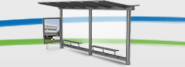
- In the near future, all Stream stops will have lighted shelters, benches, real-time arrival signs and other amenities
- Stream buses will be able to hold a green light longer, allowing the bus to get through and keeping the bus on the move for a faster trip
- Fare is the same as Pierce Transit local service (including free for ages 18 and under) and uses all existing ORCA, mobile and paper ticketing options, as well as exact cash.
Benefits of Stream
- Immediate relief for overcapacity Route 1 riders
- Makes a vital connection at Tacoma Dome Station lacking in Route 1 today
- Supports riders and the community to deliver travel time savings and frequency
What is the Difference Between Stream and Route 1?
- Route 1 is Pierce Transit’s highest-ridership route, making many stops along the Pacific Avenue/State Route 7 Corridor and running from very early in the morning until late evening, 7 days a week.
- Stream Community Line is designed to make fewer stops, and will make those stops at major intersections that have had historically high numbers of boardings for Route 1.
- Stream Community Line runs on weekdays during morning and afternoon/evening to help those riders who commute to/from downtown Tacoma and who connect to other local and regional transit services for work.
- Route 1 will continue to serve the corridor alongside Stream, with its current route path from Spanaway through downtown Tacoma and on to Tacoma Community College.
- Route 1 and Stream Community Line will share some bus stops. Stream stops will be enhanced with lighted shelters, benches, real-time arrival signs and other amenities.
- • Stream Community Line buses will have a distinct look, They’ll be easy to spot, with “Stream Community Line” branding, and “Stream Community Line” on the destination sign above the windshield, allowing riders to differentiate between Stream service and service on other Pierce Transit routes.